
March 12, 2019

Using Google Maps in the big smoke can have its issues. As you step off public transport and walk to your destination, you may realise you have been walking the wrong way. Maybe you became disorientated or it was your phone's compass playing up due to the fact you are surrounded by large metal infrastructure.
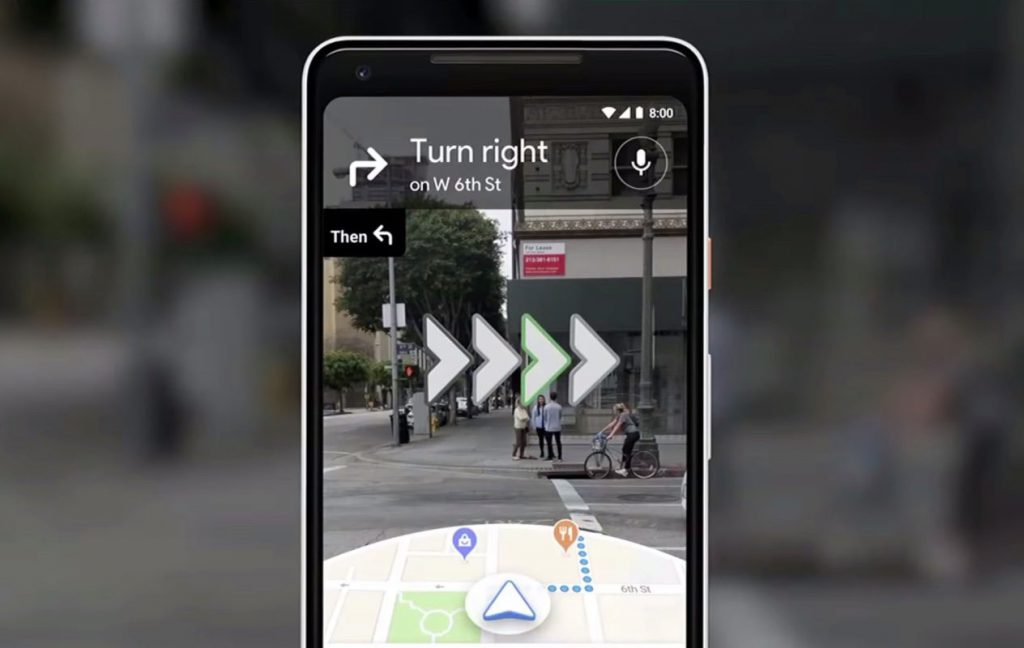
Google wants to solve this problem with its work-in-progress augmented reality mode. This will use your camera's view of the real world and will superimpose arrows and signs onto the real world, so you know exactly where to go. It uses the view of your camera and compares it to the Google Street View imagery database to figure out exactly where you are and which way you are facing. This makes up for inconsistencies from your GPS and/or compass. Currently, this app is in alpha testing stages.
It was almost a year ago that Google first announced its plans for AR walking directions at its annual I/O conference, but it has been quiet on the subject since. A lot of this time has been spent figuring out the finer points of the UI. Safety became an issue as early users tried to stand directly on top of the line when walking, even when it was not safe to do so. Google tried using floating particle effects in the air to represent paths and curves. A user commented on this and described it as if they were 'following floating trash'.
Also noted by the Google Maps team was that nobody likes to hold their phone up for a long period of time. The AR experience is designed keeping in mind that users will only need to use this in short bursts.
Using AR mode feels very much like Google Maps has for any other journey. Start by entering your destination as you normally would, then tap the walking directions button. The only difference is you tap the "Start AR" button instead of the "Start" button. Your camera's view will now appear on the screen. The app will ask you to point your camera at a building or landmark, you will notice a bunch of dots appear as it recognizes landmarks and points of interest around you. After a few seconds, the dots will fade away, which are then replaced by arrows and markers to guide you on your journey. On the bottom of the screen, you will see a small cut-out showing your location on the map, which means you don't have to switch modes see your ordinary map.
Holding your phone more parallel with the ground, Google Maps shifts back to the normal 2D map view. Hold your phone up like your reading a text message and Google Maps switches back to AR mode. Google Maps AR certainly works better in some situations than it does in others. This is to do with the view your camera has to relevant buildings and landmarks from your point of view. The clearer it can see that sort of infrastructure the more accurately the app works. If you are somewhere like in the middle of a plaza, it will probably take a few more seconds to get its bearings.
After seeing other companies using AR, Google decided their AR experience is something you should only view for a few seconds at a time. Looking at the world through your phone for a long period of time can make you a victim to what's happening around you, from thieves to walking into a pole. The city is best experienced with your own eyes anyway.
One part of this app works by using your camera; it takes that image and compresses it, then sends it to google. Once the image gets to the cloud, Google then analyzes that image and picks out the unique visual features. While Google is doing that, it is already analyzing your GPS location. From this information, Google has two points of reference, the image from your camera and your GPS location. This is enough for Google to work out exactly where you are and what you are looking at.
Currently, Google is rolling out this product to the "Local Guides", which is a community-based group that gives feedback to Google. Google currently doesn't have a time frame for this product to hit the mainstream.
Connect with iTRA to discuss your next project.
Resources
Terms and ConditionsABN: 67119 274 181